This package includes 3 maps pertaining to Lebanon's 2009 elections: - "confessional-distrib": showing the confessional geographic distribution of Lebanon's population - "election-results": showing the election results in West Bekaa/Rashaya and Metn areas. - "results&voters": showing the sectarian representation of parliamentary seats across Lebanon, the percentage of voters per electoral district, election results, and deputy representation per number of voters
Maps of businesses open in Nahr El Bared's adjacent area including food production businesses, construction and hardware industries, beauty and entertainment enterprises, and health, education and communication businesses.
This booklet comprises of the presentations and papers that were presented and discussed during the seminar that was held in Beirut in October 2015, titled “Regional Seminar on Child
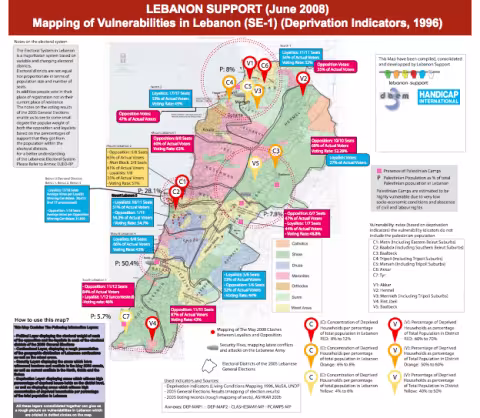
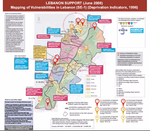
This Map Contains The Following Information Layers: - Political Layer displaying the electoral weight of each of the opposition and the loyalists in each of the electoral districts of the 2005 General Elections - Confessional Layer, displaying a rough presentation of the geogr
تشارك بما تقوم به حاليا بعض الجهات (جمعيات، تجمعات، أفراد...) في مجال التدخل التربوي (دعم اجتماعي نفسي للشباب والأطفال، نشاطات متنوعة مع الشباب والأطفال...) في الضاحية والبقاع والجنوب واحتمالات تدخل اليونسكو
This package includes two documents: - "UNICEF_Activities_22_08_06": mapping of UNICEF aid distribution activities in Lebanon, up to 22 August 2006 - "UNICEF_Distributions_Aug_21_06": mapping of UNICEF distributions across Lebanon, up to 21 August 2006